Overview
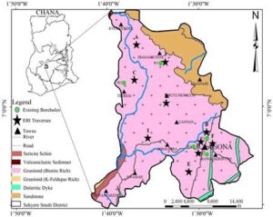
The Sekyere South District is one of the forty-three (43) districts of the Ashanti Region. The district is located in the north – eastern part of the Ashanti Region and covers a land size of 780 kilometres squared. The district shares boundaries with four districts. In the south by Kwabre, north by Mampong Municipal, east by Sekyere East and west by Afigya Kwabre districts respectively. Agona, the District Capital, and also the seat of the District Administration is 34 kilometres from Kumasi on the Kumasi – Mampong trunk road. Agona also seats the shrine of the famous Okomfo Anokye (conjuror of the famous Ashanti Golden stool). The predominant tribe is Ashanti, with other minors especially from northern Ghana. The vegetation is partly forest and savannah. There are two forest reserves namely the Offin Forest Reserve and Gye Anoma Forest Reserve. The River Offin meanders across the length and breadth of the district from the mountains at Dawu in Jamasi sub district where it takes its source through Bipoa, Afamanaso in Agona sub district, Domeabra, Krakrom in Kona sub district before leaving the district. Notably the district can boast of cocoa, timber and other crops like maize, cassava, plantain, oranges, and vegetables. It is also worthy of note that majority of the inhabitants are peasant farmers with very low income. The district has a stone query work in Kona called NAGGOT QUERY Some of the important tourist attractions in the district are the famous Okomfo Anokye shrine at Agona, Kente weaving at Agona, Kona, Jamasi, and Bepoase. Craft carvings at Kona. Some of the major endemic diseases are Malaria, Acute eye infection, cataract, Onchocerciasis, Schistosomiasis and intestinal worms.
Population distribution
The district has a projected population of 121,687 at the beginning of the year 2024. There are 112 towns and villages in the district. The District has been divided into 4 Sub-districts namely Agona, Kona, Jamasi, and Wiamoase. There are 74 outreach sites and a total of 51 Trained Community Based Surveillance Volunteers (CBSVs), and nine (9) trained Traditional Birth Attendants (TBAs)

Health
The district, with a population of 121,687 residents, is divided into 4 sub-districts. Healthcare services are provided through 12 health facilities, including 6 hospitals, ensuring that essential medical care is accessible to the population. The district also features 34 demarcated CHPS (Community-based Health Planning and Services) zones, which align with the electoral areas to offer localized health services.
Education plays a crucial role in the district, with 176 schools providing educational opportunities for the youth. In addition to formal education, the district has trained 16 Traditional Birth Attendants (TBAs) and 51 Community-Based Surveillance Volunteers (CBSVs). These trained individuals contribute significantly to maternal and child health services, as well as public health monitoring and interventions.
To extend healthcare reach, the district has established 74 outreach sites, ensuring that remote and underserved areas receive necessary health services. The district comprises 112 communities, all benefiting from the structured health infrastructure and services provided. This comprehensive health profile highlights the district’s commitment to enhancing healthcare accessibility and quality for all its residents.
transportation and communication
The general road network in the district is fairly good tarred roads which link major towns in the district which run from Kona to Jamasi, which is part of the Kumasi-Mampong trunk road then from Jamasi to Boanim, Agona to Asamang and Agona to Bepoase through Wiamoase. From Agona through Afamanaso, Bedomase to Bipoa and Domeabra to Krakrom roads are under construction. All others are feeder roads making accessibility to the hinterland very difficult.


