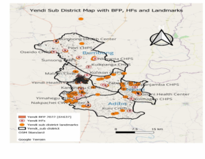
location of the municipality
The Municipality is located in the eastern corridor of the Northern Region of the Republic of
Ghana between Latitude 9º – 35º North and 0 º – 30 º West and 0 º – 15 º East. The Greenwich Meridian thus passes through a number of settlements – Yendi, Bago, Laatam, Lumpua, Gbetobu, Gbungbaliga and Nakpachei.
demography
The population of the Municipality is about 175,093 projected from 2020 population and Housing Census and is varied in terms of ethnicity with the Dagomba’s constituting the majority. The other ethnic groups include Konkombas, Akans, Ewes, Basares, Chokosis, Hausas and Moshies respectively.
demographic characteristics
The population of the Municipality is 175,093 and is varied in terms of ethnicity with the Dagomba constituting the majority. The other ethnic groups include Konkomba, Akan, Ewe, Basare, Moshie, Chokosi and Hausa. The population is largely rural. About 62% live in the rural areas while 37.4% are in towns.
The population growth rate is approximately 2.8% per annum. The main religious groupings are Moslems, Christians and Traditionalist. Migration pattern is more pronounced among the youth and especially female girls who basically travel down south to engage in ‘Kayaye’ (as potters). Out migration by young girls exposes them to all forms of sexual abuse and low female school enrolment.
greenwich Meridian
This passes through Yendi and a number of communities in the Municipality:
Map of Yendi Municipality showing Sub-municipal and location of Health Facilities.

Yendi Municipal NOP mapping 2024
| No | Municipal | Sub Municipal | Hub | Spokes | Staff Strength | Ownership |
| 1 | Yendi | Adibo | Adibo Health Center | 12 | Govt | |
| 2 | Yendi | Kuni CHPS | 2 | Govt | ||
| 3 | Yendi | Yimahegu CHPS | 3 | Govt | ||
| 4 | Yendi | Motondo CHPS | 4 | Govt | ||
| 5 | Yendi | Bumbong | Bumbong Health Centre | 9 | Govt | |
| 6 | Yendi | Tinsung CHPS | 6 | Govt | ||
| 7 | Yendi | Oseido CHPS | 3 | Govt | ||
| 8 | Yendi | Nkwanta CHPS | 4 | Govt | ||
| 9 | Yendi | Sunsong CHPS | 5 | Govt | ||
| 10 | Yendi | Yendi Central | Yendi Health Centre | 22 | Govt | |
| 11 | Yendi | Malzeri Clinic CHPS | 12 | Govt | ||
| 12 | Yendi | Kpalsondado CHPS | 4 | Govt | ||
| 13 | Yendi | Nayilifong CHPS | 7 | Govt | ||
| 14 | Yendi | Gbungbaliga CHPS | 4 | Govt | ||
| Yendi | Waliyepala CHPS | 8 | Govt | |||
| Yendi | Rayon Clinic | 10 | Private | |||
| 15 | Yendi | Kuga Community Clinic | 21 | Private | ||
| 16 | Yendi | Gnani | Gnani Health Centre | 12 | Govt | |
| 17 | Yendi | Kamshegu CHPS | 4 | Govt | ||
| 18 | Yendi | Kpanjamba CHPS | 2 | Govt | ||
Administrative sub-municipalities and health facilities
| Land Size | 1,446.3 sq.km |
| Population 2023
(Projected from 2020 PHC) |
175,093(GPHC 2020) |
| Adolescent Pop (22.4%) | 39,221 |
| Growth Rate (2.8%) | 4803 |
| Pop < 1year (4%) | 7004 |
| WIFA (24%) | 42,022 |
school
The Municipality has the following educational facilities,
1. Thirty-Four (34) Early Childhood Centers
2. One hundred and seven (107) Primary Schools
3. Twenty-three (23) Junior High Schools,
4. Two (2) Government Senior High Schools,
5. One (1) Health Assistance Training School
6. One (1) Teacher training collage
7. One (1) Vocational School


