location and size
Krachi Nchumuru District, established in 2012, is part of the nine administrative districts in the Oti Region, Ghana, with Chinderi as its capital. Geographically, it lies between latitudes 7°4″N and 8°25’N, and longitudes 0°25’W and 0°20’E, covering an area of 1,194.90 sq km. Bordered by Krachi West and Krachi East Districts to the southeast, Sene District to the southwest, and Kpandai District to the north, the district’s strategic location offers potential for investments and enhanced internal trade.
Health Facilities
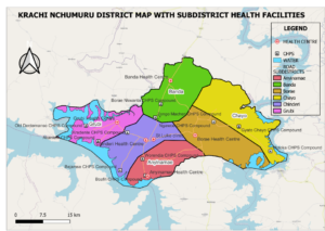
The district hosts 20 health facilities: 5 health centers, 14 CHPS compounds, and one mission facility under CHAG, spread across six sub-districts: Anyinamae, Borae, Chayo, Chinderi, Banda, and Grubi. However, it lacks a district hospital, relying on Kete Krachi District Hospital, 50km away, for hospital services. The district’s population is projected to be 84,094 in 2024, with specific demographics including children under one year at 4% (3,364), women in fertility age (WIFA) at 24% (20,182), and children under five years at 18% (15,557). The district comprises about 144 communities and is led by Mr. Mukaila Diwura as the District Director of Health Services.
Number of Health Facilities per Sub-District
|
SUB-DISTRICTS |
HEALTH FACILITIES |
|
BORAE |
Borae Health Centre |
|
BANDA |
Banda Health Centre |
|
Zongo-Macheri CHPS |
|
|
Borae Nkwanta CHPS |
|
|
ANYINAMAE |
Anyinamae Health Centre |
|
Boafri CHPS |
|
|
Worenjah CHPS |
|
|
CHINDERI |
Chinderi Health Centre |
|
Bejamse CHPS |
|
|
St. Luke’s Clinic (Hospital) |
|
|
CHAYO |
Gyato Akura CHPS |
|
Motoka CHPS |
|
|
Ngawoe CHPS |
|
|
GRUBI |
Grubi Health Centre |
|
Akaniem CHPS |
|
|
Kradenteh CHPS |
|
|
Old Dentemanso CHPS |
Figure: Human Resource per population ratio
|
Staff category |
2021 |
2022 |
2023 |
|||
|
No. of Category |
Ratio |
No. of Category |
Ratio |
No. of Category |
Ratio |
|
|
NURSE Population Ratio |
140 |
1:571 |
146 |
1:579 |
169 |
1:493 |
|
Midwife to WIFA Ratio |
29 |
1: 662 |
33 |
1:594 |
33 |
1:606 |
|
Physician Assistant Population Ratio |
4 |
1:19984 |
4 |
1:20832 |
3 |
1:20832 |
|
Doctor Population Ratio |
0 |
0:79934 |
0 |
0:81613 |
0 |
0:83326 |
Table 1: Population Structure of the Krachi Nchumuru District, 2024
|
Sub district |
Total |
< 1 year |
< 5 years |
WIFA |
Expected deliveries |
Expected pregnancies |
|
Banda |
24783 |
991 |
4585 |
5948 |
991 |
991 |
|
Borae |
13543 |
542 |
2505 |
3250 |
542 |
542 |
|
Chinderi |
13221 |
529 |
2446 |
3173 |
529 |
529 |
|
Grubi |
12302 |
492 |
5536 |
2952 |
492 |
492 |
|
chayo |
9282 |
371 |
1717 |
2228 |
371 |
371 |
|
Anyinamae |
10963 |
439 |
4933 |
439 |
439 |
439 |
|
Krachi nchumuru |
84094 |
3364 |
15557 |
20182 |
3364 |
3364 |
Accessibility and Transportation
Krachi Nchumuru District is considered hard to reach due to its unique accessibility by lake. Traveling to and from the district within a day is challenging due to limited ferry schedules and the poor condition of roads, especially during the rainy season. Many communities (around 25) are on islands, necessitating rented motorboats for transportation. Immunization mop-up activities are crucial to reaching these remote populations, contingent on funding. Transport within the district is sparse, with few cars available, making motorbikes and bicycles the primary means of transportation. An ambulance service, provided by the government in 2020, often breaks down, complicating emergency health service delivery.
Occupation
The majority of the district’s population, approximately 79.3%, are engaged in skilled agriculture, forestry, and fishery. Other occupational groups include service and sales workers (8.6%) and craft and related trades workers (6.9%).
ethnicity
The Nchumurus are the indigenous ethnic group, with a significant settler population of Konkombas, Tongu, and Hausa-speaking people. The traditional governance structure includes divisional chiefs, community chiefs, and minor settlement leaders, fostering a peaceful and united atmosphere.
Traditional Knowledge, Values, Practices, and Religion
The Nchumurus uphold various traditional values, such as celebrating the annual Yam Festival, observing traditional marriage rites, and adhering to sacred days prohibiting farming and fishing. Respect for elders, hard work, friendliness, and humility are deeply ingrained in their culture.
festival
The Yam Festival is the district’s major celebration, attracting visitors and generating revenue. It also serves as an opportunity to showcase the district’s resources to potential investors and raise funds for development initiatives.
market infrastructure
Market centers in Borae, Banda, Boafri, Akaniem, Chinderi, Anyinamae, and Kaparae are significant sources of internally generated revenue for the District Assembly.
relief and drainage
Part of the Northwestern Savannah zone, the district features flat relief with elevations between 85m and 300m above sea level. Major water bodies include the Dakar River, Volta Lake, and Oti River, crucial for household use, fishing, and transportation. These water bodies also support fish farming and rice cultivation.
vegetation
Situated in the Transitional Vegetation Savannah woodland zone, the district’s landscape consists of drought-resistant trees and economic fruit trees like sheanut, dawadawa, and baobab. The vegetation is under threat from bush burning, charcoal production, and farming activities.

In summary, the Krachi Nchumuru District, despite its challenges with accessibility and transportation, holds significant potential for development through its strategic location, cultural heritage, and natural resources. The district’s health infrastructure, though limited, strives to serve its population amidst logistical constraints


