Overview
The Mamprugu Moagduri District was curved out from West Mamprusi
District in 2012 with its political administrative capital at Yagaba. It is one of the severely deprived districts in the North East region of Ghana. The district is located within longitudes 0.35⁰W and 1.45⁰W Latitudes 9.55⁰N and 10.35. The district has a population of 66,181 (2021 GPHC).
demographics
It shares boundaries with Builsa South District in the Upper East Region to the north, North Gonja District in the Savanna Region to the south, West Mamprusi Municipal to the east, Sissala East District in the Upper West Region to the west, Wa East District in Upper West Region to the northwest and Kumbungu District in the Northern Region to the south-east.
The district has an area of 2,121.31 sqkm. an estimated population of 73,169.
Economic activities
The economic activities of the people are prodominantly farming,fishing etc due to the availbility of the black volta which passes through most part of the district. Rice is seen as a cash crop which gives more yield because of the numerous water bodies.
religion and ethnicity
Mamprugu Moagduri district is not so different from other districts of Ghana in relation to religion as the inhabitants are segregated into the threee (3) religious beliefs: Islam, Christianity and Tradiotional religions. The population distribution of these groups sees Islam as the dominating group whiles the other two (2) are sparsely distributed. The district as a young developing district has witnessed a mixture of so many ethnic groups namely: Mamprusis, Dagombas, Sissalas, Builsas,Koomas,Housas, Fulanis etc.
health
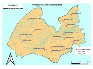
The distict has 17 health facilities, 1 polyclinic, 4 health centers and 12 Chps
compounds.


