Overview
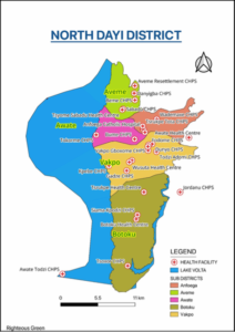
North Dayi District is one of the Eighteen (18) Administrative Districts in the Volta Region as well as one of the 7 newly created districts in the Region in the year 2012. It was carved from the old Kpando Municipality. It shares boundaries with Kpando Municipal to the north, south with South Dayi District, and east with Afadzato-South District while the Volta Lake forms the Western boundary. The District covers a total area of approximately 620 square kilometers with about 10% submerged by the Volta Lake. North Dayi District lies within latitudes 3020’N and 3.5005’N, and lies approximately on longitude 0017’E. The district had a projected population of 40,393 with 70 communities based on the 2021 population and housing census.
The District is dominated by a mix of high lands, valleys and plain grounds giving an undulating topography. The terrain is mostly steep and difficult to access. The District capital, Anfoega is easily accessible by road such as the one, which runs from Kpando through Anfoega to Accra. Anfoega, the District capital, is about 51 km away from Ho the regional capital. The District Health Directorate is however located at Vakpo.
food crop production
Food crops such as maize, rice, plantain, cassava, yam and other vegetables especially garden eggs, okro and chili pepper are grown both on subsistence and commercial level. Crop production is largely rain-fed even though there are water sources suitable for irrigation.
housing, water and sanitation
Potable water, which is one of the basic necessities of life, is not a major problem in the district. As much as 70% of the people have access to potable water in the district. The rest depend on the Volta Lake for water and others on streams.
The sanitary conditions of the district is on the average. Some houses have poor environmental conditions resulting from poor drainage, stagnant waters, erosion and unkept environment.
health care
The Health delivery system in the district is carried out by staff working in public and mission health facilities made up of one (1) Mission Hospital, Nine (9) CHPS compounds and seven (7) Health Centers (Source: District Health Directorate, 2024)
The District has 46 outreach points where Reproductive and Child Health Services are rendered. Healthcare delivery in the District operates through five (5) networks of practice namely Vakpo, Anfoega, Awate, Aveme and Botoku. There are 23 CHPS zones where other outreach services are delivered. The health systems in the district have an integrated mode and operates with massive emphasis on stakeholder engagement.
There are Community-based Surveillance Volunteers (CBSV) located in all communities.
occupation
The people living in the area are mainly subsistence farmers, petty traders and white clay molders with a few civil servants as well.
religion
Most of the inhabitants of the district are Christians with various denominations followed by traditional worshipers.
education
The district can boast of three (3) Senior High Schools and Fifty eight (58) other institutions providing basic education to the population. There are no tertiary institutions in the district.
local governance
The local government structure of the district operates with a district assembly located in the district capital (Anfoega). Other available local governance offices include a district magistrate court, Commision of Human Rights and Administrative Justice (CHRAJ), Electoral Commission, Social Welfare Department and the Ministry of Food and Agriculture.
security
The district has a police command located at Anfoega with another sub unit located at Vakpo. There are community watchdogs as well located in selected communities


