Overview
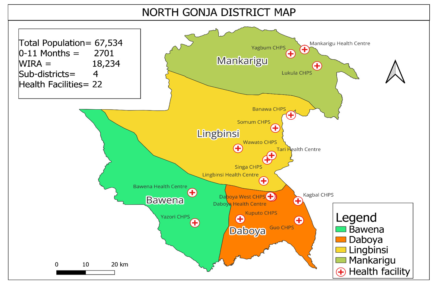
The North Gonja District was established in 2011, after being carved out from the West Gonja District. It spans an area of approximately 4,845.5 square kilometers, and is bordered by the West Gonja and Wa East districts to the west, Tolon District to the east, Mamprugu-Moagduri and Kumbungu districts to the north, and Central Gonja to the south. Within the district, the White Volta River serves as a natural boundary, dividing the Daboya sub-districts’ catchment communities into two. On one side of the river lie the Daboya Health Centre, Daboya West CHPS, and Kuputo CHPS, covering an estimated population of 6,772. On the other side, there are the Kagbal and Guo CHPS compounds, situated on the overbank with a total of fourteen (14) communities.

Population
The 2024 district population stands at 67,534. This population is spread across the district’s 11 square kilometers, resulting in a population density of approximately 11 individuals per square kilometer. The population of the district is largely composed of the Gonja ethnic group, although there are also smaller populations of Tampulma, Mamprusi, Hanga, Dagomba, and Fulani.
Socio-cultural Activities
The district is situated within the traditional area of Wasipe, with Daboya serving as both the administrative and traditional capital. The traditional authority in the district is vested in the overlord of the Wasipe area, known as the “”Wasipe-Wura””. The Wasipe traditional area is one of the five major divisional areas within the Gonja Kingdom.
Demography
The district is characterized by the flow of the White Volta River, which experiences flooding during the peak of the rainy season. This flooding is further compounded by the annual spillover of the Bagri Dam in Burkina Faso. Other significant streams in the area include Tarchali and Tari, which have the potential for irrigation and fish farming. However, access to water can be challenging as most of these streams dry up after the rainy season.
The North Gonja District is well endowed with rich arable lands with the major economic activities in the area including; farming, cattle rearing and trading. Major crops cultivated include maize, millet, groundnuts, soya beans, rice and sorghum. Fishing is done in the White Volta River though fishermen say they do not get enough catch of late.
The district is also noted for its rich smock weaving in Ghana which serves as a tourist attraction. There are salt deposits on the White Volta just around the district capital, but mostly mined during the dry season. The district has three functional markets at Mankarigu, Lingbinsi and Tari which serve as sources of revenue generation for the District Assembly. The tourist‟s sites in the district are the Bawena Range, Kpariya waterfall and the beautiful smock weaving in Daboya.
Education
In terms of education, the district has a single teacher training college, two senior high schools – Wasipe SHS and a Community Day SHS, as well as 13 junior high schools and 43 primary schools. However, the literacy rate in the district is relatively low, with only around 25% of the population being literate.
Health Infrastructure
The health infrastructure in the district comprises of 5 health centers and 17 CHPS, out of which 9 have compounds and 7 lack structure. The Daboya Health center serves as the sole referral point for the district, owing to its laboratory capabilities. However, there is a severe shortage of essential health personnel, with only one Physician Assistant (PA) serving the entire district. We urgently request for the deployment of PAs and other critical staff to augment the workforce in the district.
Health Institutions and Catchment Population
The district has Twenty-two (22) health facilities comprising, five (5) health centers, and Seventeen (17) functional CHPS compounds. There are fifteen demarcated CHPS zones as compared to fifteen electoral areas. All the facilities with offer 24-hour services to the communities they serve.
Population
The population in the district especially in the remotest settlements is served by seventeen (17) functional Community-Base Health Planning and Services (CHPS) facilities. These cover eighty one (81) communities and a population of about 42,039. Additional source of access to health services in the district is the many outreach service points created in many large communities scattered in the rural and remote settlements.


